Museum Math and Mapping Fun
We recently received the Flower Garden Banks National Marine Sanctuary traveling exhibit.
 It should be fun to have this in the museum and it get's me to thinking about things like "Where is the marine sanctuary, relative to my current location?"
That is, what direction and how far from where I am standing or, say, from a specific location such as the City by the Sea Museum.
If we knew the "coordinates" of the two places, we could use a calculator to find the direction and distance.
We can answer that using some simple online tools to find the information we need and to help perform (and explain) the calculations needed. We can use our smartphone (or just a plain compass) to find the direction and we can use the calculator to express the distance in our preferred units (e.g., miles).
So first off, where is the FGBNMS? In other words, what are it's coordinates?
 That's easy to find on the Internet. (Hint: search for "flower garden banks location"). The answer is 27.8841° N, 93.8147° W.
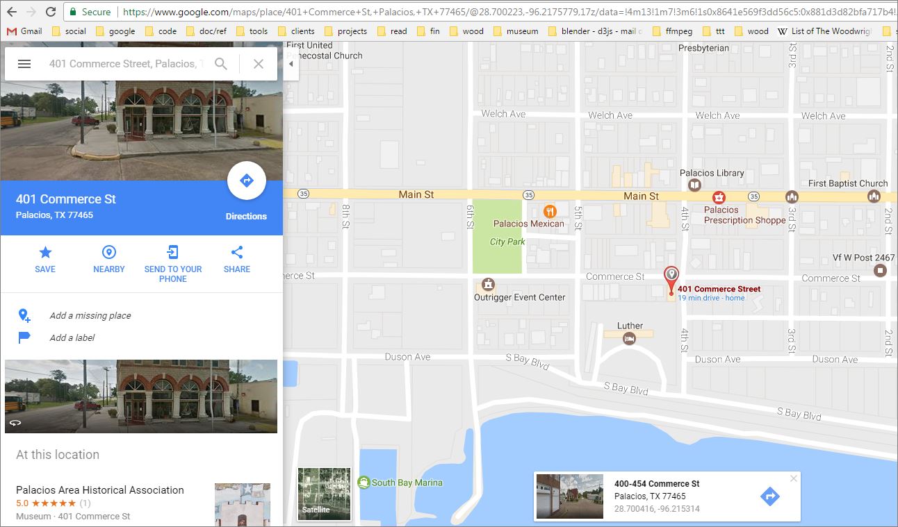
OK. Now what's the coordinates for the CBTSM? We can use a tool like Google Maps to find that or, in this special case, look up the coordinates for the R.J. Hill building in Wikipedia! :)
 To do this in Google Maps, find your location by typing in your address or by moving the map and clicking to create a pin. Then click on the pin to see your coordinates as in the picture above and to the left.
In our case, Google Maps says that the CBTSM is located near 28.700416, -96.215314. Wikipedia claims that the location is 28°42′01″N 96°12′54″W. Both are close in value, relative to the building and the street block
 Note that Wikipedia uses the Degrees-Minutes-Seconds notation for coordinates, while Google Maps uses Degrees in decimals format. Google also assumes that directions are always North and East and uses a minus sign instead of South or West.
So now all we need is to find a calculator that will tell us the distance and directions. How can we find that? Hint: search for "direction from two coordinates".
 Here's the first one I found. It's cool because it provides an easy to use calculator and also gives an explanation of how the calculations are made so we can dive down into the mathematics behind the scenes.
 The answer to our question is about 252 km, at a bearing of 110 degrees. I used my smartphone's compass utility app to point myself in the right direction. A regular compass would do, or just estimate if you know which way is North.
Kilometers are about 3/5 ths of a mile and so this is about 156 miles.
For pirates hanging out around the museum, that makes it about 300,000 paces to the southeast, matey!
 It should be fun to have this in the museum and it get's me to thinking about things like "Where is the marine sanctuary, relative to my current location?"
That is, what direction and how far from where I am standing or, say, from a specific location such as the City by the Sea Museum.
If we knew the "coordinates" of the two places, we could use a calculator to find the direction and distance.
We can answer that using some simple online tools to find the information we need and to help perform (and explain) the calculations needed. We can use our smartphone (or just a plain compass) to find the direction and we can use the calculator to express the distance in our preferred units (e.g., miles).
So first off, where is the FGBNMS? In other words, what are it's coordinates?
 That's easy to find on the Internet. (Hint: search for "flower garden banks location"). The answer is 27.8841° N, 93.8147° W.
OK. Now what's the coordinates for the CBTSM? We can use a tool like Google Maps to find that or, in this special case, look up the coordinates for the R.J. Hill building in Wikipedia! :)
 To do this in Google Maps, find your location by typing in your address or by moving the map and clicking to create a pin. Then click on the pin to see your coordinates as in the picture above and to the left.
In our case, Google Maps says that the CBTSM is located near 28.700416, -96.215314. Wikipedia claims that the location is 28°42′01″N 96°12′54″W. Both are close in value, relative to the building and the street block

So now all we need is to find a calculator that will tell us the distance and directions. How can we find that? Hint: search for "direction from two coordinates".
 Here's the first one I found. It's cool because it provides an easy to use calculator and also gives an explanation of how the calculations are made so we can dive down into the mathematics behind the scenes.
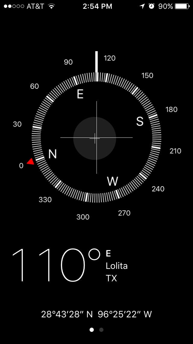 The answer to our question is about 252 km, at a bearing of 110 degrees. I used my smartphone's compass utility app to point myself in the right direction. A regular compass would do, or just estimate if you know which way is North.
Kilometers are about 3/5 ths of a mile and so this is about 156 miles.
For pirates hanging out around the museum, that makes it about 300,000 paces to the southeast, matey!
Labels: bearing, coordinates, distance, exhibit, flower garden banks, mapping, math, museum, Palacios, STEM, texas, tools, whereami
posted by Markus Sandy at 1:39 PM
0 comments
![]()
![]()


